The Maps Below Illustrate how Frenton Changed from 1990 to 2012. Summarise the Information by Selecting and Reporting the Main Features and Making Comparisons Where Relevant.
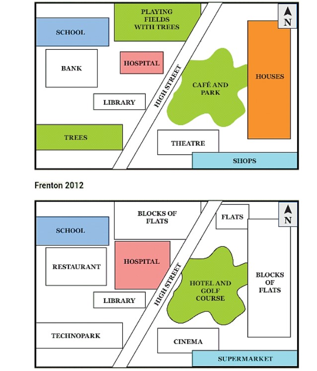 The two maps show the changes that took place in Frenton between 1990 and 2012.
Overall, it can be seen that a lot of changes occurred in the second map of Frenton. The hospital saw an expansion, while the school, library, and high street remained unchanged.
In 1990, the town consisted of a school, playing fields with trees, a bank, a hospital, a library, trees, a high street, a cafe, a park, a theatre, houses, and shops. To the north of the town are houses with a cafe and a park directly opposite. South of it is the theatre and shops, and a high street which separates the facilities from others like the school, playing fields with trees, the bank, the hospital, the library, and trees.
In 2012, only the school, library, high street, and hospital remained from the original site. The most significant change was the expansion of the hospital, which occupied the space that was left between it and the surrounding facilities, such as the bank, playing fields with trees, the library, and the high street. Furthermore, flats were built to take the place between the high street and houses. Blocks of flats, a restaurant, a technopark, a cinema, a supermarket, a hotel, and a golf course replaced the others that were built in 1990.