The maps below show the town of Lynnfield in 1936 and then later in 2007. Summarise the information by selecting and reporting the main features, and make comparisons where relevant.
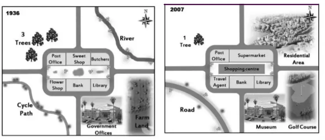
The two maps show the transformations done to the town of Lynnfield over 71 years, beginning in 1936.
Overall, the natural landscape was modified to make way for residential areas and modern amenities.
The river which ran to the eastern side of the town was filled up to pave the way for the establishment of a residential area, whilst a supermarket was erected on the space previously occupied by the sweet shop and butcher in proximity to the residential area. In addition, the number of trees on the northwestern side had declined to one over the reported timespan.
Regarding the southeastern part of Lynnfield, profound amendments had been made with the farmland having been transformed into a Golf course with the subsequent renovation of Government Offices into a Museum. Even though the bank and Library remained unmoved, the flower shop became the Travel Agent;
Moreover, the open space that existed in the middle of the business area now housed the shopping centre. Finally, the cycle path to the Northwestern side was upgraded into a graphite and tar road.
Follow Us on IELTSFever Facebook
Also read: The Maps Below Show Pancha Village in 2005 and 2015